Day 7: Shape of the United States
Objective:
The student will develop map skills by identifying the shapes of the United States and Virginia on maps and globes (1.4c)
Materials:
- Blown-up outline of the U.S. cut into five pieces (one piece for each table group)
- Projector and Computer which can access the Place the States Activity
- Access to Google Earth
- Globe
- World Map
Events of Instruction:
- Distribute blown up pieces of blank U.S. map. Each group receives a puzzle/map piece.
- Instruct students to color the land green and the water blue on their piece of the U.S.
- Instruct each group to put the pieces together to create a map of the U.S. on the floor
- Ask students what the map represents
- Where are we on the map?
- Ask a student to stand on the piece of the map where Virginia is located
- Ask if anyone has ever visited another state. Place students on the map accordingly.
- Gather students on the rug for whole group instruction
- Ask for a volunteer to find the United States on a globe
- Ask for a volunteer to find the United States on a world map
- Ask students if anyone knows how many states are in the United States?
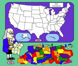
- Pull up "Place the States" activity on the projector/smart board
- Allow each student to place one or two states on the map using the outlined map. Indicate the state's name and ask if anyone knows a fact about the state.
- Instruct students that you are going to go on a tour of the United States. Lead each table group around a portion of the perimeter of the U.S. map on the floor, singing "I went walking. What did you see? I saw Georgia with its peach trees! I went walking. What did you see? I saw Florida and sat on the beach. I went walking. What did you see? I saw Virginia. That's home to me," etc.
- Once each group has had a turn to "tour the U.S."- visiting 3-4 states each, instruct students to return to their seats
- Using Google Earth, manipulate and orient the map of the globe on the smart board/projector.
- Instruct students individually to come up and swat the United States using a fly swatter on the map's projection
- Manipulate the map's orientation for each student.
Differentiation:
- For students who are struggling to situate states, allow classmates to assist during the "Place the States" activity
- In organizing groups for the U.S. outline mapping activity, pair advanced students with students who may have difficulty
- To challenge students who seem to grasp the material quickly, ask them to locate specific states during the Fly Swatter activity.
Assessment:
- Students will complete a puzzle depicting the shape of the United States
- Students will situate the states within their respective shapes on a map of the United States
- Students will locate the shape of the United States on various world maps using Google Earth
